By Yupeng Liu, Chong Chen, Jiajia Li, Wei-Qiang Chen*
By Yupeng Liu, Chong Chen, Jiajia Li, Wei-Qiang Chen*
Landscape Ecol
https://doi.org/10.1007/s10980-020-01084-8(0123456789().,-volV() 0123458697().,-volV)
Abstract
Context
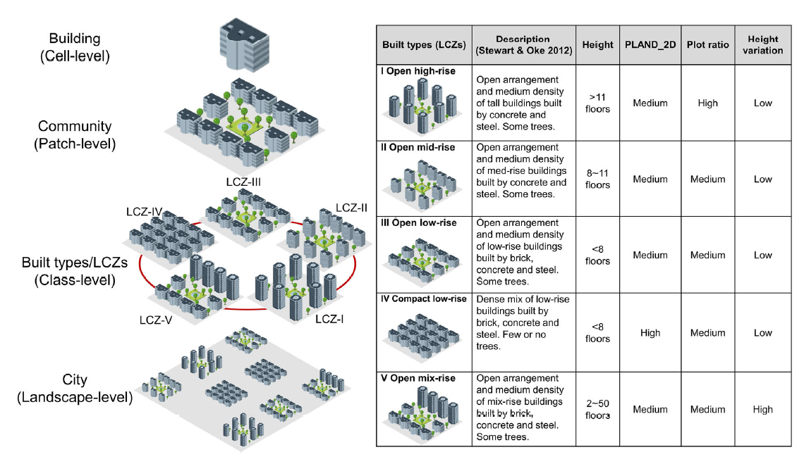
The key attributes of landscape pattern include composition and configuration, which can be depicted by landscape/spatial metrics. An emerging pathway is leveraging vertical data to advance three-dimensional (3-D) spatial metrics to interpret landscape attributes and quantify 3-D patterns.
Objectives
We introduced a suite of spatial metrics to recognize 3-D morphological characteristics of residential communities and examine their temporal changes.
Methods
Seventeen 3-D spatial metrics were designed and computed at patch-, class-, and landscape-levels based on building footprints and height information in geographic information system (GIS). These metrics characterized 3-D forms of residential communities, including number, area, height, shape, and diversity. These 3-D features were further used to recognize five typical built types based on the scheme of local climate zone (LCZ) and quantify their 3-D morphological changes with rapid urbanization.
Results
The 3-D spatial metrics performed well in describing vertical and volumetric characteristics of residential communities and distinguishing five typical built types in Xiamen, China. Our results indicated that architectural styles of residential communities changed from homo- to mixed-rise buildings and from compact to open arrangement with rapid urbanization.
Conclusions
Both 2-D and 3-D features are key attributes of the landscape. Our results showed that 3-D spatial metrics were not only useful tools for quantifying surface patterns but also key complements to vertical feature characterization, offering advantages in representing urbanization over the existing indexes. Growing 3-D datasets have great potential to develop more valuable metrics for characterizing spatial features, capturing ecological processes, and understanding drivers in various landscape contexts.
Keywords
Urban form, Spatial pattern, Spatial metric, Local climate zones (LCZs), Remote sensing, Urban sustainability, High-resolution urban grids (HUGs), Industrial ecology